

Why would Hillside mcmodulars & spot zoning be disastrous for Onteora Hill?
— WHAT IS SPOT ZONING? —
The “classic” definition of spot zoning is “the process of singling out a small parcel of land for a use classification totally different from that of the surrounding area for the benefit of the owner of such property and to the detriment of other owners.“ 1
Spot zoning is, in fact, often thought of as the very antithesis of plan zoning. 2 When considering spot zoning, courts will generally determine whether the zoning relates to the compatibility of the zoning of surrounding uses. Other factors may include; the characteristics of the land, the size of the parcel, and the degree of the “public benefit.” Perhaps the most important criteria in determining spot zoning is the extent to which the disputed zoning is consistent with the municipality’s comprehensive plan.
Spot zoning is a reward for the rich, connected, and unconcerned.Dr. C. Tom Williams, Director on LA-32NC Board, President of Citizens Coalition for a Safe Community (LACo but based on the Inglewood Oil Field and Culver City, since 2008)
Prof. P. Whittemore points out “… zoning practices are an easily manipulated advantage for which ever political interest is paying the most attention: “Zoning only works to favor who has the power, and that might be just whomever is participating” (KCET, Exceptions Rule: The Dirty Little Secret of LA’s Zoning Code).
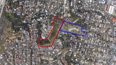
Many L.A, neighborhoods owe their names to long-ago real-estate moguls like Henry Huntington and I.N. Van Nuys, who subdivided unspoiled land and exploited it to the fullest. Others, like Elysian Heights or Miracle Mile, were conjured up as marketing tools to lure prospective homeowners to a would-be paradise. Eagle Rock is one of the few areas named in honor of the natural beauty that surrounds us. Apart from the bluff dominated by the Eagle Rock itself, the ridge beyond Kerwin Place and Round Top Drive is now the last unspoiled hillside our community has left, where nature has been allowed to stay intact — where the trees and plants and animals that have been here for thousands of years still have sanctuary. If Leap of Faith is awarded a spot-zoning designation, this is what Eagle Rock — and all of us who proudly call it home — will lose forever. Ed Leibowitz, writer, Eagle Rock Resident
— THE COMMUNITY WANTS THE RE20 TO REMAIN WITH NO ZONE CHANGES. —
Why do we NOT want spot-zoning on the Onteora site; changing it from our current RE20 to RE11? Squeezing 14 multi-dollar homes onto a treacherous hillside is greedy. Alex & Kristy Koplin, Eagle Rock residents
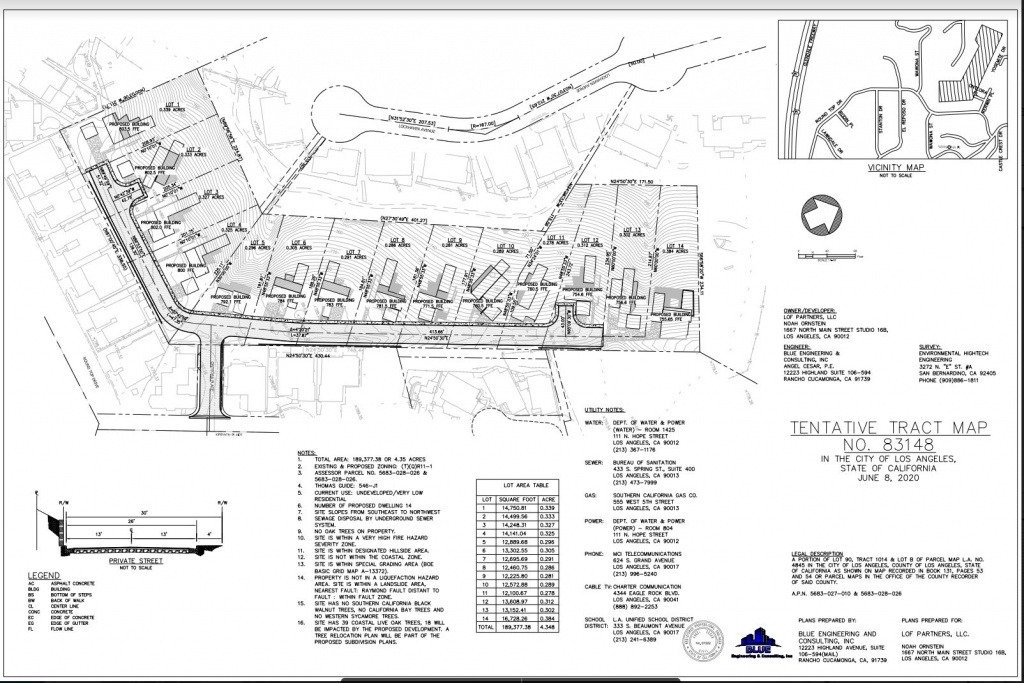
Recognizing there are NO RD1.5, RD2, R2 and C zones for the existing Onteora hillside, Leap of Faith Partners, LLC (the developer) is locked into cubed and stacked home “infill” style structures with distinct, compact building footprints, smaller lot areas (from existing lots), 3-4 story level homes with minimal street front and setback requirements. For any lot that fronts on a SUBSTANDARD HILLSIDE LIMITED STREET, the minimum Front Yard setback is five feet (Baseline Hillside Ordinance: pg.5). The 2020 TT Vesting Map 83148 shows no such setback but many possible irregularities. Zoning issues and substandard, land-locked parcels demonstrate exactly the situation that BHO 184,802 has been adopted: to control out-of-scale, incompatible, and over-development of high-density residential structures in hillside zones.
— HISTORY OF ZONING & SPOT ZONING CHANGES ON ONTEORA HILL —
In the 1970s land parcel (5683028026) remained an RE20 allowing for 2-4 single family homes on the property. Permitting was denied by the City and opposed by then Councilman Art Snyder due to the single entry/exit onto the property from a cul-de-sac, at Kerwin Place on the hillside.
In 2007-2008 Onteora Way, Los Angeles, CA 90041 (Parcel # 5683028026) was owned by Thaer Mahmoud (28611 Saragosa, Laguna Niguel, CA and Majdi Bitar (418 Andover Dr. Burbank, CA) (California Modern Homes, LLC) sought City approvals to build 9 single-family dwellings on that hillside property. Case No: APCE-2007-5295-ZC ENV-2006-9508 MND. Among the many municipal codes that needed effectuation, Zoning for the land parcel required change from RE 20 to an RE11. To accomplish this Mr. Mahmoud hired Mr. Victor Griego of Diverse Strategies for Organizing, INC (DSO) a PR Firm recommended by, and long associated with Council District #14 Jose Huizar’s office. In subsequent years, DSO did fund raising for Mr. Huizar.
An incomplete MND, et al, was submitted, and a Public Hearing was held resulting in the following: the requested zoning was disapproved, but a recommendation to change the Zone from RE20 to (T-tentative) (Q – qualified) Re-11-1 was decided. Everything else was approved. Mr. Mahmoud’s request to develop this land base, with the aid of Mr. Griego and Mr. Huizar, moved swiftly through the City’s cumbersome planning process. Jose Huizar’s office quickly approved the project and it easily passed through the East LA Planning Commission. Many neighbors at the time, cried foul, but were financially unable to hire the appropriate legal representation. The project was never completed because of the Housing Crisis of 2008.
— ONTEROA HAS BEEN A START/STOP/START PROJECT AND WAS CITY-TERMINATED IN 2018. IT RECOMMENCED IN 2020. —
The property was sold in 2015 to Leap of Faith Partners, LLC (LOF) – Noah Ornstein, principal. All approved permits and planning were transferred in this sale. Later LOF purchased an abutting parcel (5683027010 that has an R1 zone) and announced to neighbors a subdivision was now planned to put in 14 prefabricated modular units on the site. For reasons unknown to the Onteora Hillside Alliance, the project was terminated in 2018 after three time extensions, and the entire project cancelled. The zoning reverted back to RE20. LOF reactivated its development plans in 2020 with requests for another zoning change from RE20 to RE11 for both parcels (APCE 2020 -6555ZC HCA and TT Vesting Map 83148 HCA); and this includes the environmental request to cut down at least 29 PROTECTED LIVE OAK Trees (ENV: 2020-3136 EAF).
-- Other Start/Stop Eagle Rock Developments: "PillarHenge" and Failed Fair Park
What is clear are companies shielded by an LLC designation can cut a project loose at any time and for many reasons, including financial ones, and never follow through. There are two such “eyesores” in Eagle Rock (after ‘permitted’ 25+ years ago) – one at the eastern base of the Onteora hillside (Fair Park Ave.) the other on Colorado Blvd. known to locals as “Pillarhenge.” Both remain incomplete to this day.
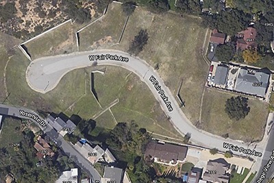
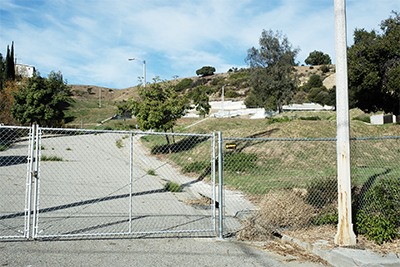
— The Failed West Fair Park Ave Development
The abandoned development just east of Onteora Hill was permitted 25+ years ago. Yet after they slice and diced the hillside all that exists today are massive concrete retaining walls, cracked concrete roads, crumbling sidewalks and dilapidated street lamps. This property has also changed hands multiple times over the years with no sign of completion or any hints at forward progress.
— Eagle Rock’s Infamous “Pillarhenge”
In 2008, developers in Eagle Rock put the kibosh on a planned mixed-use development on Colorado Boulevard—they abandoned the building foundations and left behind an ugly spine of tall concrete pillars. In the past twelve years, the property has changed hands multiple times and residents have had to drive by the eyesore as it fills with garbage and graffiti and acquired the name “Pillarhenge”. It is still abandoned to this day with no set plans to either revert it to greenspace and turn it into a park, as local advocacy group Friends of Pillarhenge Park wishes, or to complete the development.

— WHY IS A ZONING CHANGE INCONSISTENT FOR OUR EAGLE ROCK HILLSIDE? —
”RE11 will increase the number of homes from RE20, therefore increasing the amount of cars and traffic navigating to the area. RE11 vs RE20 will provide homes that do not conform to the exiting neighborhood…”Maritza Fernandez, Eagle Rock resident
Proposed Zone Changes (APCE 2020-6555 ZC HCA) (Vesting TT MAP 83148 HCA) on the hillside FAIL to follow the guidelines of our Northeast Los Angeles Community Plan (I, pp.1-9; II-1) – a long-term general plan that contains seven elements for consideration, including land-use, circulation, housing, conservation, open spaces, noise, and safety.
A Zoning Change:
- Does not sustain environmental and social equity in our area. Eagle Rock has been and remains a diverse population of people and cultures.
- Increases density and the resulting gentrification violates Eagle Rock’s “strong architectural heritage” of C. 1920-1960 homes. (pp.1-3)
- Violates Northeast Los Angeles guidelines that oppose “Incompatibilities of land uses and scale of development that detract from established neighborhood or community character “(pp.1-8).
- Promotes “Destruction and deterioration of community resources, including neighborhood scenic viewsheds, open space corridor…. “ (pp.1-9) on the last green space hillside in Eagle Rock.
- Promotes the disruption of the hillside’s “generally outdated infrastructure….” (p.1-9)
- Violates guidelines that disallow “The encroachment of incompatible uses and inappropriately-scaled [prefabricated, modular, in this case] development into single-family and low density neighborhoods” (pp. 1-9)
- Gives the developer an opportunity to strategically target “ low density hillside development” (pp 1-10)” solely for profit.
We do not need the zoning changed. The traffic on the hill is REALLY bad now. We don’t need more. The streets are too small no parking ECT. STOP THIS CONSTRUCTION.J. Wear, Eagle Rock resident
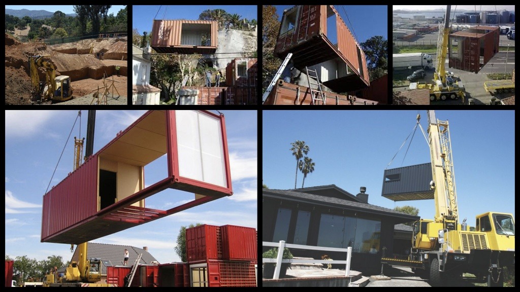
— HILLSIDE MCMODULARS – THE NEW MCMANSIONS —

Should the crisis for affordable housing compel Community Planners to misunderstand what they are voting on if the McModular project before them is in fact high-end housing? And, they remain single-family units.
Will hillside ridgelines, view vistas be disabled with the propagation to infill our Onteora hillside, or any hillside for that matter, with Modulars?
There is a burgeoning pattern, practice and development precedent to infill hillsides in Los Angeles which will resurrect old school Hollywood Hills/Laurel Canyon type stilt construction-design – NOT in the single-family character and scale of existing Eagle Rock housing. ARE WE NOW LEVERAGING PREFABRICATED MODULARS IN Los Angeles TO INCREASE DEVELOPER PROFITS? It gives the veiled appearance, a socio-economic “cocktail” if you will, of advancing such initiatives as sustainability, the need for housing (but in this case, NOT affordable housing), less neighborhood disruption.
— THE PROPOSED DEVELOPMENT DOES NOT: —
- Minimize grading operations
- Minimize Dirt truck haul routes and hauling
- Shorten construction schedule impacts on existing neighborhood
- Optimize resources to be less destructive.
- Provide affordable housing
- Offer a safety net hazard in a Very High Fire Hazard Severity Zone. Think light-weight construction materials, consider attic or open spaces filled with lightweight trusses supporting a roof over floor joists that are attached to some type of board (maybe gypsum) by a highly flammable glue. Will they be covered with a flammable siding or as a fire chief calls them a “solidified gasoline wrap.” (Gallagher, 2009. Fire Engineering, “The Dangers of Modular Construction”)
Converting one of the last pristine ridgelines in NELA into an overcrowded, overpriced, over- glorified ‘prefab trailer park’ is the LAST type of housing that Los Angeles needs, and would be a shameful legacy for anyone who has such disregard for Eagle Rock.Mark Gilbert, Eagle Rock resident
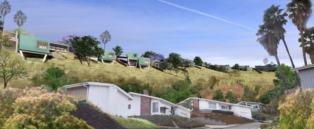
A house on stilts by any other name remains a stilted house! Will Leap of Faith’s Modulars be the new Los Angeles-anointed ‘beasts’ of our Eagle Rock/Onteora Hillside? Stilts are a great way to place a unit on unstable ground. Since the unit is built up, off the ground, it’s up to the stilts themselves to give stability rather than the ground underneath. This allows houses to be built in otherwise unstable places and minimize a unit’s footprint, allowing for more homes, hence greater density. And these Onteora prefabs are going to be placed on land that the city acknowledges are prone to landslides? Ludicrous.
K.Whitaker, PhD. Eagle Rock resident
–AN ILL-ADVISED, POTENTIALLY DANGEROUS, OPPORTUNISTIC PLAN AT 4875 W ONTEORA WAY —
— THE NEIGHBORHOOD’S CONCERNS —
- New units are expected to meet the demands of current high income Los Angeles market prices.
- It is not the BEST use of the land.
- No share of regional jobs within a commute through high-transit public transportation. Hillside living most often requires private vehicle transportation to and from schools, commercial retail outlets and employment.
- Incompatible modular units with existing 1960 hillside stick and mortar homes on the Onteora Hillside. Homes at the baseline of this hillside include Lockhaven, College View, Onteora Dr., Yosemite Drive, Yosemite Way constitute a part of Eagle Rock’s historic 1920-1950s district that includes early California bungalows. (See NELA Community Plan, I, pp1-8)
- No socio-economic benefit to the community of Eagle Rock.
- DANGEROUS SINGLE ENTRY/EXIT from a small alley-like street emptying into a hillside cul-de-sac, Kerwin Place. 14 units = 28+ cars 2X a day
- HIGH DANGER during emergency evacuations from a single entry/exit.
- 13% steep grade at Kerwin Pl./ Round Top juncture poses traffic hazard and pedestrial safety with 28+ additional cars. (City says anything over 6-7% is considered steep!)
- “Y” turnarounds at the north and south ends eliminate safe access and passage for large fire trucks, other emergency vehicles, and city-vehicles (trash, et al) in a Very High Fire Hazard Severity Zone.
- Adds stress and possible damage to the existing 1960s infrastructure such as older water mains, gas lines, above ground telephone, cable and electrical connections. Who pays for the connections? Damage? Tax increases in Northeast Los Angeles?
- Only 7 police cars assigned to a 39 square mile area in Northeast Los Angeles poses a dangerous reality for emergency response.
- Geology and soil concerns. Raymond Fault Zone (Zimas.org) with Topanga shale/sandstone is sloped downward to the East and upward to the West. This could have an effect on the placing of units with caissons and drilling/fracking into the ground. Below the sandstone is either an older shale OR a faulted droop-down block of Puente (young shale). Either way, the contact could have good ground flow water thus adding to the susceptibility of landslides downhill onto Lockhaven backwalls in an earthquake.
- Subdivision road maintenance
- PARKING SPILLOVER onto cul-de-sac Kerwin Place and on Round Top Dr.
- SEWAGE. Where is it connected? How is it pumped?
- STREET LIGHTING and how it abuts neighbors’ backyards.
- STORM AND DRAINAGE on steep ridgelines. Lower NW-erly slopes are above Lockhaven Runoff Diversion. Kerwin Pl. – Lockhaven St. – Woodland and Ridgeline – What were the reasons in 1960s for building a V-ditch along the Lockhaven easterly slope property lines from the top of the Onteora property?
- Elevations: NW side 700 Ft.-640’ to NW downhill. On the SW end 810’-790-770’ NE end. S/SE side: 810’-790-775’ at hillside crest and run into backyards of Kerwin and Round Top residences. How will storm waters, water main breaks be diverted away from neighboring homes? Moreover, concerns that in certain storm periods (experienced in 2016, 2017 and 2020) especially with the altering/grading of the hillside land base for this subdivision, water runoff could exceed the capacity of existing or planned storm water drainage systems with polluted water runoff.
- FIRE HYDRANT PLACEMENT and water pressure concerns.
- GRADING DOWN OUR HILLSIDE and infilling of dirt.
- Residents exposed to AT LEAST 24 MONTHS of dust, dirt, noise, danger of cranes lifting modules onto the property.
- HAUL ROUTES
- LOOKING FOR FAIR, HONEST, COMMUNITY-PROTECTED ASSESSMENTS be completed by elected and volunteer City officials assigned this project. (Real concerns for recent publicly identified reports of corruption and collusion between developers and City officials in CD#14 and beyone; some of whom have now pleaded guilty to such activities. (See The Eastsider: 5/28/20; City Watch 5/25/20.) We look to your careful, objective assessment to safeguard our neighborhood rights and quality of life.